Home page  |  Flights to Crete  |  Car rental in Crete  |  Holiday apartments  |  Info Crete  |  Road maps  |  Distances in Crete  |  Contact us

Versione in Italiano   Greek version   German version   Version française

<<<<<<<<< >>>>>>>>

Version française   German version   Greek version   Versione in Italiano

Makrigialos

is a village in the south-east of Crete, with a resident population of 760 people (source Wikipedia.gr, national census of 2011), which is part of the Municipality of Ierapetra since 2010.


Its main inhabited center stretches, facing south, along the main road that runs between the coast, overlooking the clear waters of the Libyan Sea,

and the first hilly reliefs that lead to the mountain known as "Crucified Lord" (in greek "Αφέντης Σταυρομένος" - Afendis Stavroménos) which, with its maximum altitude of 1476 meters, gives the region an interesting footprint of hills and mountains and provides a good shelter from the weather from the north during the winter.

Click to enlarge the view of Makrigialos

In Makrigialos winters are mild and very short and the climate is temperate for most part of the year.


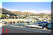
Under these optimal conditions, the main activity is agriculture, characterized by wide and extensive presence of horticultural greenhouses planted with tomatoes, eggplants, peppers and bananas............. with installations that in some cases are located a few meters from the beach as if to compete with the other

Tourist map of the Lassithi

major resource of the area, tourism.


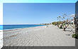
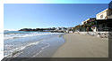
Tourism that in the last thirty years has gained a lot of space here, and in some cases did so with a few large Hotel Resorts, attracted not only by the beautiful beaches existing in the area (like that of Kalamokanià that you will find at the entrance of the village coming from Ierapetra or as the central one, almost a kilometer of

coastline mostly sandy, called "Makrigialos" or "long shore", which gives the name also to the village), but especially by the variety of proposals that a holiday in Makrigialos can ensure.

From the equipped beaches to the quiet coves, from the island of Chrissì with its tropical colors (loved by mass tourism and reachable daily by ferry from Ierapetra) up to the deserted island of Koufonissi, rich in history (but difficult to

reach and reserved for the lucky few), from the old mountain villages to the hiking trails ..... here really the proposal is wide and for all tastes.

In Makrigialos you will find a pharmacy, the bus stop of the regional Ktel, some small supermarkets, souvenir shops of various kinds, a gasoline station and a bank equipped with cashpoint.

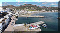
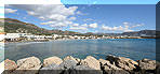
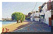
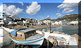
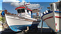
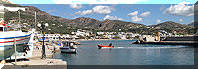
Pleasant the stroll in its small marina, animated by tavernas and cafes and starting point in summer of a private motorboat that, by reservation only, makes fishing trips and organized tours to the islands of the Libyan Sea (Chrissì-Gaidouronisi) and the beaches of the beautiful deserted islands Koufonissi.

Poseidon - Daily trips by boat to fish and to visit the nearby islands of the Libic Sea at the extreme south-east corner of Crete

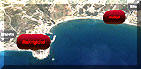
Makrigialos is located at coordinates

+35° 2'1 6.777 " North, +25° 58' 20.725" East and these are the distances from the main towns of Crete :

  • Chania center - 260 km. - provincial road 90 till the junction of Pahia Ammos and then the state road E75 along the north coast (travel time 3 hours and 35 minutes)

  • Heraklion center - 120 km. - provincial road 90 till the junction of Pahia Ammos and then the state road E75 along the north coast (travel time 1 hour and 49 minutes)

  • Agios Nikolaus - 58,7 km. - provincial road 90 towards Ierapetra and till the junction of Pahia Ammos and then the state road E75 along the north coast (duration 1 hour and 6 minutes)

  • Ierapetra - 25,6 km. - (travel time 30 minutes)

  • Sitia - 33,5 km. - provincial road 90 in the direction Analipsi-Lithines (travel time about 41 minutes)

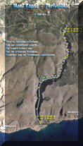
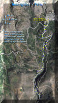
From Makrigialos are possible several and interesting day trips, for places and walk itineraries as :

  • the path through the gorges of Aspropotamos that leads to the village of Pefki (trekking of moderate difficulty)

  • the coastal monastery of Monì Kapsà - 9,4 km. of coastal road towards east, direction Analipsi-Gouduras (travel time about 12 minutes)

  • from Monì Kapsà starts the path through the gorges of Perivolakia (but only for expert walkers)

  • the stretch of coast from Ferma to Koutsounari that includes the bay and beach of Kakì Skala - follow the coastal road to the west for 14 km. towards Ierapetra (about 20 minutes)

Or the mountain villages of :

  • Schinokapsala - 13,5 km. - direction west on the road towards Ierapetra till Agios Panteleimonas and then to the north (travel time about 20 minutes)

  • Orinò - 16,1 km. - direction west on the road towards Ierapetra till Agios Panteleimonas and then to the north (travel time about 24 minutes)

  • Stavrohori - 9,5 km - direction west on the road towards Ierapetra till Kotsouras and then to the north towards Tsikalaria (travel time about 14 minutes)

  • Agios Ioannis - 24,2 km -  direction west on the road towards Ierapetra till Kotsouras and then to the north (travel time about 35 minutes)

  • Agios Stefanos - 6,8 km. - direction east towards Analipsi and then to the north (travel time about 13 minutes)

And also more places of tourist interest such as :

  • the abandoned village of Etià with the ruins of the Venetian villa Demezzo - 16,7 km. along the road towards Analipsi, Lithines turning right just before Papagiannades direction Armeni (travel time 20 minutes)

  • the beaches of Xerocampos - 43,5 kilometers along the road towards Analipsi, Lithines turning right just before Papagiannades towards Etià-Armeni-Ziros-Hametoulo (travel time about 55 minutes)

  • the Minoan Palace of Kato Zakros - 50,8 kilometers along the road towards Analipsi, Lithines turning right just before Papagiannades, direction Etià-Armeni and Handras, here crossing the village towards to the wind farm and the ruins of Voila and then in direction to Katelionas-Sitanos-Karidi and the descent towards Adravasti and Zakros (travel time about 55 minutes)

  • the monastery of Moni Toploù, the palm forest of Vai and the beaches and the ruins of Itanos - 57,2 kilometers along the road towards Analipsi-Lithines-Sitia, here through the city and turning on the seafront towards Palekastro and then past the tourist complex Dionysos/Zoe, turning to the left after 1.5 km. (travel time 1 hour and 10 minutes).

Versione in Italiano   Greek version   German version   Version française

<<<<<<<<<< >>>>>>>>>>

Version française   German version   Greek version   Versione in Italiano

Versione in Italiano   Greek version   German version   Version française

<<<<<<<<<< >>>>>>>>>>

Version française   German version   Greek version   Versione in Italiano

go to Index Lassithi

Car rental in Crete  |  Holiday apartments in Xerocampos  Information & Reservations

©Web-Master Andrea Marini andrea18@otenet.gr - marinator2001@yahoo.com


Registered in the Register of the Touristic Companies of The Tourist Greek Organisation (EOT) since 25.09.2013 with authorization number 1040E 6061 01822 01

Licenza Creative Commons
All texts, graphics and images in this page are property of Andrea Marini - www.xerocamboscreta.com